
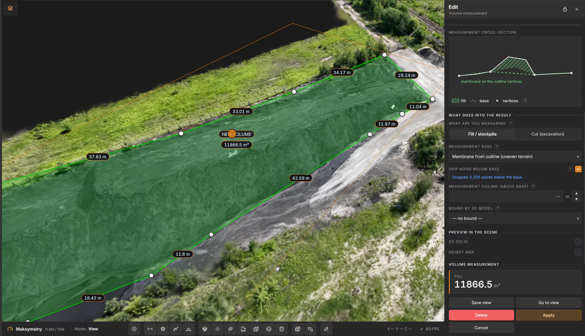
Knowing how much material sits on the yard is basic plant management – for inventory, purchasing and month-end reporting. Yet stockpiles are still often measured by walking the yard or estimated by eye. With an up-to-date 3D scan of the yard, you can measure the volume of a stockpile in a few minutes, from your desk, and every colleague sees the same result.
This guide shows how to do it in PlantScope, our web platform for working on 3D scans of industrial plants, and what to look out for to get a reliable result.
What stockpile volume measurement is used for
Measuring the volume of bulk materials – aggregates, coal, biomass, raw materials and intermediate products – is used, among other things, for:
- stocktaking at financial year-end and during the year,
- planning purchases, deliveries and production,
- monitoring material consumption and comparing stock levels between measurements,
- settling earthworks – excavation and fill volumes.
Methods of measuring stockpile volume
The volume of material on the yard can be determined in several ways:
- Estimating from the dimensions of the pile – quick but approximate; it only works for regular shapes.
- Ground survey – measuring selected points on the surface of the material, e.g. with a total station or a GNSS receiver.
- 3D laser scanning, photogrammetry and drone surveys – capture the entire surface of the material as a point cloud or 3D model, on which the volume is calculated.
A 3D scan captures the full shape of the material, not just selected points. The same scan can also be used for other measurements and work across the plant.
Why measure stockpiles on a 3D scan
- No walking the yard. You measure in the browser, on the scan, instead of on site.
- Repeatable. The outline and settings are saved, so the next measurement uses the same method.
- Shared. Colleagues and management see the same number, the outline and the report.
What you need
An up-to-date 3D scan of the area loaded into PlantScope – a point cloud, a 3D mesh or a Gaussian Splatting model. The more recent the scan, the closer the result is to what is on the yard today. You can use existing data or have the scan done for you – InventaXR provides 3D scanning of industrial sites using laser scanning, photogrammetry and drones.
Step by step
- Open the plant and choose Volume measurement on the toolbar at the bottom of the screen.
- Click the points of the outline around the stockpile, one by one. You need at least three points, and the outline must not cross itself. Press Enter to finish.
- Choose what you are measuring: Fill / stockpile or Cut / excavation.
- Choose the measurement base – the surface the volume is calculated from (see below).
- Optionally: skip noise below the base, set a ceiling above the base, or bound the measurement by a 3D model.
- Check the preview: the cross-section, the 3D solid and the height map show what is being counted.
- Read the result – fill, cut and balance – and download the report.
Choosing the right base
The base is the biggest single source of error in stockpile measurement, so it is worth choosing it consciously:
- Lowest point of the outline – for piles standing on flat, level ground.
- Fitted plane – for a sloped yard, where the ground under the pile is flat but tilted.
- Membrane from the outline – for uneven terrain; the base follows the outline points like a stretched sheet.
If the scan contains points below the base (noise, holes in the ground), turn on Skip noise below the base so they do not distort the result.
Converting volume to tonnes
A measurement on the scan gives you the volume of the material. For stocktaking and settlements you often need the mass – multiply the volume by the bulk density of the material (e.g. in tonnes per cubic metre). Bulk density depends on the type and grading of the material, its moisture content and how compacted it is, so it is worth determining it for each material stored on site and updating it periodically.
Tips for reliable results
- Draw the outline just outside the toe of the pile, on clean ground.
- Use the membrane base whenever the ground around the pile is not flat.
- Re-measure after every new scan of the yard to track how stock changes over time.
- Save the view, so colleagues can open exactly the same measurement.
- Need to show the result to someone outside the company? Share it with a guest link – no account required.
Frequently asked questions
Which materials can be measured on a 3D scan?
Any material visible on the scan and stored in an open yard or inside a building – e.g. aggregates, sand, coal, biomass, clinker, raw materials and waste. The same method measures excavation and fill volumes in earthworks.
What kind of scan is needed?
A point cloud, a 3D mesh or a Gaussian Splatting model covering the whole measurement area. PlantScope loads PLY, SOG, LAS and 3D Tiles files, among others.
How often should stockpiles be measured?
The result reflects the state of the yard on the day of the scan. How often depends on your needs – e.g. before year-end stocktaking, for monthly reporting or after large deliveries.
Can the result be shared with people outside the company?
Yes. A guest link opens the selected measurement in a web browser, with no account required.
Does PlantScope require any software installation?
No. PlantScope runs in a web browser on desktop and tablet.
Measure your stockpiles in PlantScope
PlantScope runs in a web browser, on desktop and tablet. Besides volumes it measures distances, areas and paths and lets you lay out new piping on the real plant. InventaXR can also scan the yard or the whole plant for you – see 3D Scanning. See PlantScope or book a demo.